Success through cooperation:
MDS Use Cases of our members


Latest Use Cases
Solita
Intelligent Urban Ecosystem for Human centric city living

Solita's 'Intelligent Urban Ecosystem' integrates various devices, data sources and advanced technologies to create more efficient, liveable and sustainable cities. This concept supports cities and organisations by leveraging data and analytics to develop tailored use cases.
Solita offers e2e solutions that can be seamlessly combined with existing modules.
More information
Mobias
Danger spots in traffic
We need your consent in order to display additional content embedded from YouTube.
Give us your permission by an additional click and we will gladly provide this content. We would also like to point out that we cannot rule out the possibility that the data collected may be transferred to countries outside the European Union, in particular to the USA. There is no adequacy decision by the European Commission for the USA. We have concluded so-called standard contractual clauses with Google LLC/LinkedIn Corporation/ Twitter Inc. Further information hereto can be found in our Privacy policy under „Cookies“.
AI-driven road hazard predictions - Swarmnect leverage vehicle data, historical accident records, and environmental information for safer roads.
They enhance road safety with OEM vehicle data, historical accident info, and environmental data. This allow to predict hazards, alert drivers through software defined vehicle applications, and provide insights for government preemptive precautions.
More Information
Esri
Connecting data for more road safety

Esri develops the classic "digital twin" into a "living digital twin" by integrating sensor data. Telematics data from car manufacturers enables adaptation to the current traffic situation. The Living Digital Twin can be widely used, e.g., in traffic planning, police and rescue operations as well as by logistics and transport companies.
More information
MegaBITS
MegaBITS project creates Cycle Data Space
The MegaBITS project is creating the Cycle Data Space, a Europe-wide open data platform that connects municipalities. It consolidates cycling data (e.g., bike lanes, traffic volume, accidents, sharing services, weather, and air quality) and infrastructure data (such as charging zones, parking facilities, or construction sites). The goal is to enable smart solutions for cycling, urban planning, and sustainable mobility—like dynamic route optimisation or demand-driven infrastructure—through secure data use and standardised interfaces.
More information
Insurance companies
Pay how you drive

The use of data from connected vehicles enables insurance companies to offer their customers better rates. By collecting and measuring various data (e.g. kilometers driven, braking and acceleration behavior, speed etc.), drivers can secure lower rates if they have no accidents or claims, but also if they drive well and safely.
This incentive for the insured also leads to less risky driving behavior and supports foresighted driving, which in total ensures greater safety on the road and can contribute to environmentally friendly driving. The working group (OEMs and insurers) develops scalable standard processes for the use cases PAYD, PWYD, PHYD and FNOL as well as solutions for a transparent and simple consent process.
DeepVolt
DeepVolt Location Intelligence Assistant

The DeepVolt Location Intelligence Assistant (DLIA) is an AI-powered web tool that empowers cities and businesses to find profitable sites for EV charging.
The cutting-edge AI-powered solution is revolutionising the way electric vehicle (EV) charging stations are sited. By leveraging comprehensive data analytics, DLIA empowers cities and businesses to strategically position charging infrastructure for maximum impact.
More information
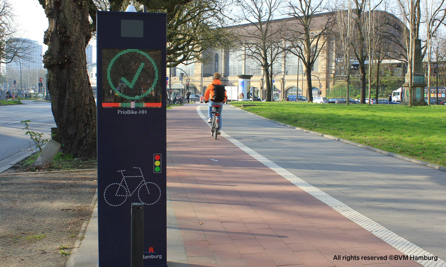
Initiative for safe roads and the City of Hamburg
PrioBike-HH: Enhancing Cyclist Safety

In collaboration with the Initiative for Safe Roads GmbH and the City of Hamburg, an innovative system for improving traffic safety was tested at a critical intersection in Hamburg’s HafenCity (Am Sandtorkai / Großer Grasbrook). The goal was to use digital technology and optical signals to prevent car and lorry turning accidents and significantly enhance cyclist safety.
More information
More Use Cases
BMW
Local Hazard Information
We need your consent in order to display additional content embedded from YouTube.
Give us your permission by an additional click and we will gladly provide this content. We would also like to point out that we cannot rule out the possibility that the data collected may be transferred to countries outside the European Union, in particular to the USA. There is no adequacy decision by the European Commission for the USA. We have concluded so-called standard contractual clauses with Google LLC/LinkedIn Corporation/ Twitter Inc. Further information hereto can be found in our Privacy policy under „Cookies“.
In agreement with customers, BMW vehicles can independently detect dangerous situations such as heavy rain or black ice with the help of a large number of sensors and transmit this information to the BMW backend.
The more vehicles reporting potentially dangerous situations, the more accurately the situation can be assessed. This service makes a significant contribution to road safety. Additional data offered via the Mobility Data Space can be used to achieve even better data coverage, provide more targeted warnings to endusers, and thus increase overall road safety.
highQ
AI-based optimisation of current mobility offers
We need your consent in order to display additional content embedded from YouTube.
Give us your permission by an additional click and we will gladly provide this content. We would also like to point out that we cannot rule out the possibility that the data collected may be transferred to countries outside the European Union, in particular to the USA. There is no adequacy decision by the European Commission for the USA. We have concluded so-called standard contractual clauses with Google LLC/LinkedIn Corporation/ Twitter Inc. Further information hereto can be found in our Privacy policy under „Cookies“.
The goal of the highQ MobilitySuite app is to promote sustainable, cross-provider, and multimodal transportation options for people and goods. Through an integrated incentive system, the application motivates users to sustainably change their own mobility behavior.
The highQ MobilitySuite obtains weather data from the Mobility Data Space. This data is linked with data on mobility services and infrastructures. In this way, users get a comprehensive overview of the most favourable mobility options in each case – and additionally benefit from various types of rewards if they choose the sustainable option.
Mercedes-Benz
"Parking Monitoring" and "Slippery Road"
We need your consent in order to display additional content embedded from YouTube.
Give us your permission by an additional click and we will gladly provide this content. We would also like to point out that we cannot rule out the possibility that the data collected may be transferred to countries outside the European Union, in particular to the USA. There is no adequacy decision by the European Commission for the USA. We have concluded so-called standard contractual clauses with Google LLC/LinkedIn Corporation/ Twitter Inc. Further information hereto can be found in our Privacy policy under „Cookies“.
Real-time Parking Events for optimised parking space search and planning (Parking Monitoring)
With the Parking Monitoring interface, Mercedes-Benz provides anonymised parking events of connected Mercedes-Benz vehicles based on their Park-In and Park-Out movements.
Members in the Mobility Data Space thus receive anonymised parking data such as GPS position, time and vehicle size. The anonymised, voluntarily provided parking data of connected Mercedes-Benz vehicles enables, for example, the notification of free parking lots for end customers searching for a parking space. In addition, the parking data also offer potential applications for municipalities and cities for parking space planning. In this way, the secure data transfer realised by the Mobility Data Space contributes to an increase in user-friendliness in mobility.
The connected car as mobile weather station - Using vehicle data for higher road safety in winter road maintenance (Slippery Road)
Public authorities, traffic control centres and road maintenance depots (e.g. the Zollernalbkreis district) are increasingly relying on digital solutions to control the deployment of winter road maintenance services and make roads safer. For this purpose, Mercedes-Benz uses the intelligence of the vehicle fleet as mobile micro weather stations.
Mercedes-Benz vans and passenger cars that are equipped with Car-to-X technology and whose owners have activated Live Traffic Service and agreed to the sharing of data provide the necessary data for this purpose. If the ESP® or ABS sensors of these vehicles detect slippery road conditions, this information, along with position data, is sent to the Mercedes-Benz Cloud in real time via the mobile network. This anonymised and validated information is made available in real time on the Mercedes-Benz dashboard and via Mercedes-Benz OneAPI.
In future, this will enable the deployment of winter services in a more target-oriented manner, to optimise the use of road salt and to make mobility safer in the long term. In addition to Mercedes-Benz vehicle data, the Mobility Data Space enables the secure integration of non-vehicle data, such as weather maps from the Deutsche Wetterdienst (DWD), in order to provide road maintenance depots with an even more holistic picture of road conditions and thus increase road safety.
More Data Offerings
Mercedes-Benz vehicle data for improved road safety for all road users - Mercedes-Benz Car-to-X Hazard Warnings provide hazard warnings in real time (Local Hazard Information)
Mercedes-Benz has been using mobile networking technologies as standard since 2013 to transmit hazard warnings from vehicle to vehicle ("Car-to-Car"). Mercedes-Benz vans and passenger cars that are equipped with Car-to-X technology and whose owners have activated Live Traffic Service and agreed to the sharing of data detect a variety of different hazardous situations, such as heavy rain, the end of tailbacks, broken-down vehicles or heavy braking. Many of these hazards can be detected automatically by Mercedes-Benz passenger cars and vans without any driver activity due to the seamless integration of the Car-to-X system into the vehicle systems. For hazards that are not or not yet automatically detectable, an efficient manual reporting option has been created. Animals on the road or wrong-way drivers can be reported to the Mercedes Cloud at the touch of a button. With the Local Hazard Information interface, Mercedes-Benz offers aggregated data on validated and local hazard information from Mercedes-Benz vehicles. Other members in the Mobility Data Space can access this sensor-based, anonymised data, which is made available with customer consent, in order to offer services with the aim of making mobility safer in the long term. Mercedes-Benz is taking a further step to increase road safety based on data.
Information on the current weather situation and road conditions (Micro Weather)
With the Micro Weather interface, Mercedes-Benz provides a wide range of anonymised information about the current weather situation at GPS level. The data mapped on defined road sections is validated and merged by a specially developed algorithm. The Micro Weather dataset is the perfect complement to the data from static weather stations to successfully compensate for their limited locality. Cities, municipalities or providers of navigation, weather or car-sharing services are provided with valuable insights, which can increase the safety of road users.
Information on longitudinal waviness of road surfaces (Waviness)
Profile evenness is one of the decisive quality features of roads and influences driving comfort and safety. In many countries, road construction authorities are obliged to record the longitudinal ripple every 4-5 years with high-resolution measurements by engineering firms. Mercedes-Benz data can optimally complement the regular measurements. The data gives cities, municipalities, road authorities or road maintenance departments an insight into the development of the road surface, even between the high-resolution measurements - and this is automated by means of almost real-time data from the networked Mercedes-Benz vehicle fleet. The data is provided in accordance with the ISO standard International Roughness Index 10 (IRI10).
Information on safety-critical points in the road network (Road Safety Hotspots)
With the Road Safety Hotspot interface from Mercedes-Benz, safety-critical points in the road network can be identified, analysed and displayed. Based on high-quality data from the ADAS sensors in the Mercedes-Benz customer fleet, a risk model is created that indicates dangerous situations and near misses in traffic and helps to take the right measures and start proactive planning.
Information on Traffic Sign Infrastructure (Traffic Signs)
With the Traffic Sign interface, Mercedes-Benz creates an overview of the traffic sign infrastructure and can be used for the targeted and thus efficient maintenance of traffic signs as well as for any application and innovation in the field of infrastructure. Based on the data set, a traffic sign register with ad-hoc warnings can be developed if a traffic sign has been damaged or removed. Traffic sign recognition is one of the most important data products on the way to a fully digitized road and is therefore part of driver assistance systems (ADAS). Traffic signs increase road safety by informing the driver about speed limits, possible hazards such as black ice, upcoming construction sites or pedestrian crossings.
[ui!] Urban Mobility Innovations
Information on the occupancy of parking spaces (OptiPark)
We need your consent in order to display additional content embedded from YouTube.
Give us your permission by an additional click and we will gladly provide this content. We would also like to point out that we cannot rule out the possibility that the data collected may be transferred to countries outside the European Union, in particular to the USA. There is no adequacy decision by the European Commission for the USA. We have concluded so-called standard contractual clauses with Google LLC/LinkedIn Corporation/ Twitter Inc. Further information hereto can be found in our Privacy policy under „Cookies“.
For municipalities that want to reduce parking search traffic and achieve a more balanced use of existing parking spaces, the OptiPark solution from Urban Mobility Innovations provides real-time and forecast data on the occupancy of parking areas.
This can be used to provide optimal information to drivers who want to get off or transfer at P+R parking locations or in touristic areas. With the help of the Mobility Data Space, other data sources, such as sensor information from vehicles, can be used for the OptiPark solution, alongside existing parking sensors such as barriers or cameras, in order to achieve more accurate real-time and more precise forecast data.